

AQUA is a water quality database aggregating data from field campaigns, open sources, satellite feeds, and government programmes including NOAA, into a single structured environment for acquisition, management, and visualisation.
- Water Resource Managers
- Environmental Regulators
- Researchers
- Insurers and Financiers
Water Resource Managers
Water quality data is collected across disconnected campaigns, systems, and geographies, and rarely structured for comparison. AQUA captures any water quality data point, on land or at sea, and aggregates it by station, parameter, or campaign within a single queryable environment.
Temporal comparison is built in, so change over time is visible without manual reconciliation across datasets. Coverage extends to geographies where monitoring infrastructure is limited or absent.
The result is a structured, searchable record that supports analysis, reporting, and long-term trend identification at a scale no single monitoring programme can achieve independently.
Environmental Regulators
Regulatory decisions depend on data that is current, comparable, and not confined to what individual monitoring programmes can cover. AQUA aggregates water quality data from government feeds, satellite observation, open datasets, and field campaigns into one structured environment, queryable by station, parameter, or campaign.
Temporal comparison is native to the platform, making it possible to assess change against baselines without manual data reconciliation. Cross-border and cross-jurisdiction analysis becomes tractable when the underlying data is consolidated and consistently structured.
Compliance assessment, standards-setting, and incident response are all stronger when the evidence base is independently sourced and comprehensive.
Researchers
The limiting factor in water quality research is rarely the question. It is access to data at sufficient scale, coverage, and consistency. AQUA captures water quality data points on land and at sea, aggregated by station, parameter, or campaign, and structured for direct analysis.
Temporal comparison across datasets is built in, removing the reconciliation work that consumes research time and budget. Historical depth and global coverage support baseline establishment and trend analysis that localised datasets cannot sustain.
Cross-regional comparisons become methodologically sound when the underlying data is structured consistently from the point of ingestion.
Insurers and Financiers
Environmental risk is difficult to price or underwrite when the data is fragmented, self-reported, or confined to sites with established local monitoring. AQUA aggregates water quality data from satellite sources, government programmes, open datasets, and field campaigns, queryable by station, parameter, or campaign across any location on land or at sea.
Temporal data is structured for comparison, making it possible to assess site conditions against historical baselines rather than point-in-time snapshots. Site-level environmental profiles can be generated for locations anywhere in the world, independent of what a borrower or policyholder submits.
Due diligence becomes faster, more consistent, and grounded in independently sourced data.
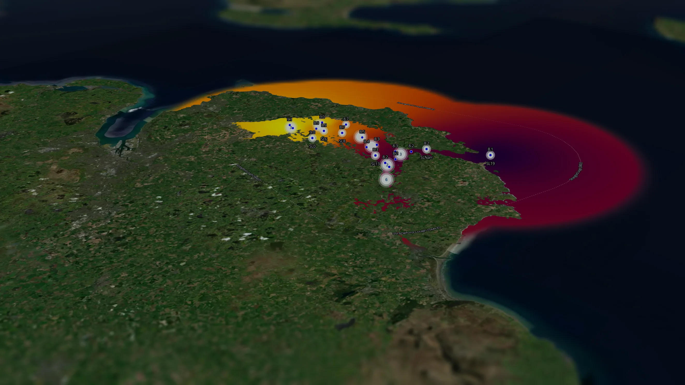
Every parameter. For any water body.
AQUA maps water quality data across rivers, lakes, coastal waters, and open ocean, drawing from thousands of monitoring stations and campaigns worldwide. Each point represents a real measurement: a parameter, a location, a moment in time, queryable across the full dataset. The result is a geospatial record of water quality at a scale that transforms how analysts, regulators, and researchers access and interrogate environmental data.
Millions of parameters. Instantly structured.
AQUA holds large aggregated water quality datasets, spanning field campaigns, satellite feeds, open sources, and government programmes worldwide. Any query surfaces relevant parameters across stations, locations, and time, structured and ready for analysis. What appears as a handful of data points is a fraction of a dataset built to support decisions at genuine scale.
Let's work together
Ready to transform your aquaculture operations with data-driven intelligence? Get in touch with our team.
- Farming
- Insurance
- Finance
- Governments & Regulators
- Certification
- Supply chain
- Conservation & NGOs
Know your farm. Know your risk.
Aquaculture operations face growing pressure to improve risk profiles to investors, regulators and buyers alike. Longline brings geospatial intelligence to risk management, environmental footprints and due diligence, giving farming businesses the clarity to operate with confidence and evidence to back it up.
Price what you can see. Trust what you can verify.
Insuring aquatic risk without reliable intelligence is guesswork. Longline gives insurers the geospatial tools to assess exposure, verify operations and support underwriting decisions grounded in data, not assumptions.
Lend and invest with your eyes open.
Whether you're structuring debt or deploying equity, operational due diligence in aquatic industries demands more than a site visit. Longline provides the geospatial intelligence to audit operations, assess risk and support financing decisions with the evidence they require.
The impact is only as good as the data behind it.
From carrying capacity assessments to licensing and environmental oversight, effective aquatic governance depends on being able to see clearly. Longline provides governments and regulators with geospatial intelligence to make policy decisions that are evidence-based, defensible, and built for the long term.
Scale your standards. Don't compromise them.
Certification bodies face a growing challenge: how to maintain rigour as the industries they serve expand. Longline provides the digital infrastructure and geospatial tools to scale certification processes, drive innovation and ensure standards hold up at any volume.
You can't assure what you can't trace.
Buyers, retailers and sourcing teams are under increasing pressure to demonstrate where their product comes from and how it was produced. Longline brings geospatial intelligence to chain-of-custody assurance, traceability, and impact measurement, so every link in the chain can be verified.
Good intentions need good domain knowledge.
Conservation outcomes depend on being able to measure what's changing, where and why. Longline works with NGOs and conservation bodies to deliver data-led impact assessments, support jurisdictional approaches and bring geospatial intelligence to the places where development innovation matters most.