
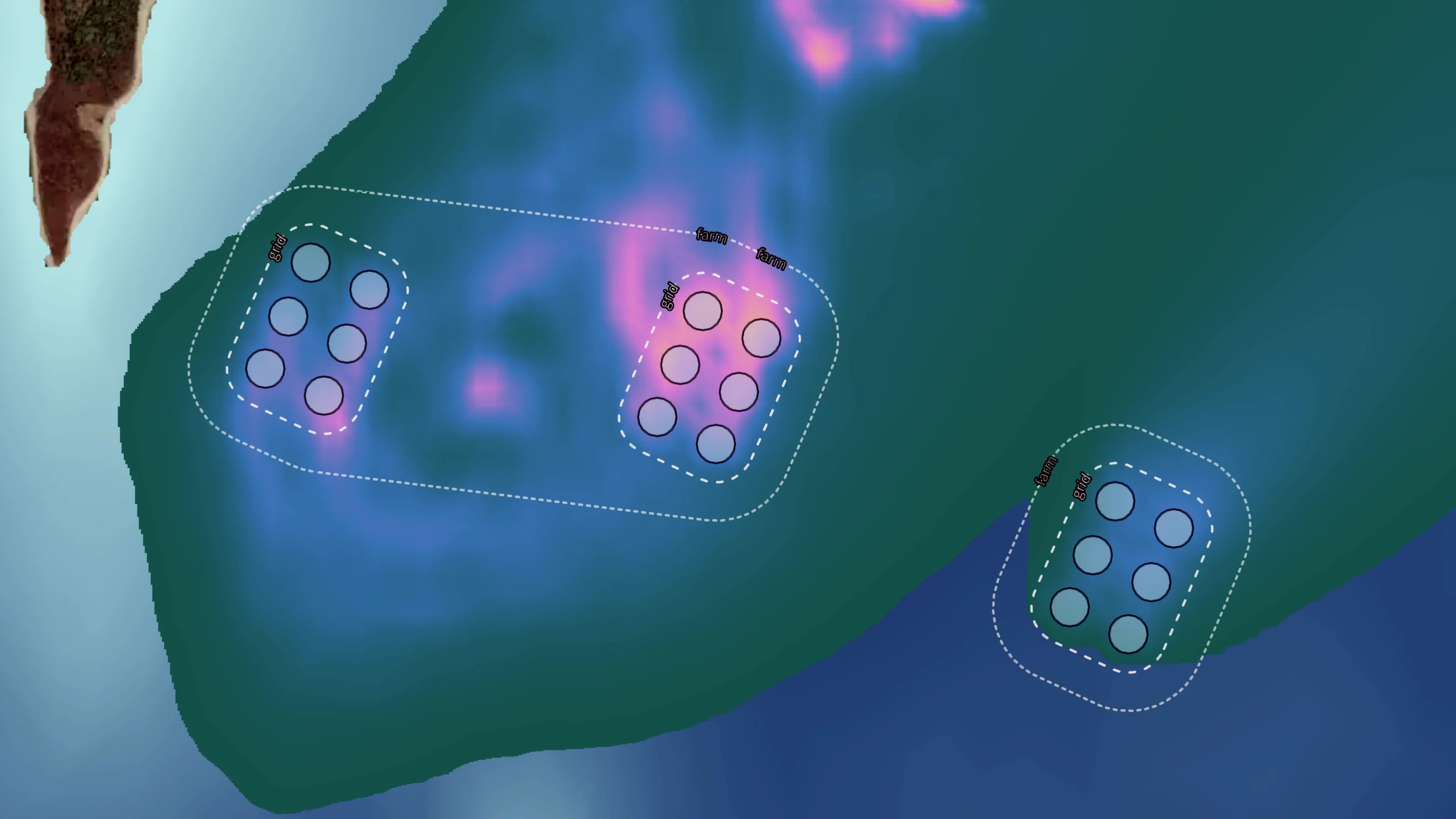

FINS quantifies the environmental footprint of marine cage aquaculture operations using a comprehensive parameter set spanning organic loading, dissolved nutrients, water quality, and production variables. The platform supports compliance assessment, scenario planning, and stress testing at both farm and regulatory scale.
- Public sector
- Farmers
- Supply chain
- Certifiers
Public sector
Licensing decisions for marine cage aquaculture require evidence of what a farm's environmental footprint will be, not just what operators report. FINS provides regulators with modelled footprint data for individual sites and for the cumulative effect of multiple operations within a shared water body.
Carrying capacity assessments, sensitivity analyses, and threshold tests can be run using site-specific physical and biological parameters. The outputs provide a defensible evidence base for permit conditions and ongoing regulatory oversight.
For agencies overseeing clusters of farms in enclosed or semi-enclosed water bodies, FINS supports the aggregate analysis that individual farm reports cannot deliver.
Farmers
Understanding where a farm's environmental footprint falls relative to its permitted boundaries is fundamental to compliance and to production planning. FINS models that footprint using the farm's own production parameters alongside the physical conditions of the surrounding environment.
Production scenarios can be evaluated before they are implemented. Changes to stocking density, species selection, or production cycle length can be assessed for their footprint implications, reducing the risk of regulatory non-compliance before it materialises.
FINS is not a substitute for environmental monitoring. It provides the modelling layer that makes monitoring data interpretable and supports forward planning grounded in environmental evidence.
Supply chain
Buyers and sourcing teams under pressure to verify the environmental credentials of their supply base need data that goes beyond self-certification. FINS provides modelled footprint evidence for marine cage operations, giving supply chain partners a technical basis for environmental assessment.
Farm-level footprint profiles can be compared across species, production systems, and geographies on consistent terms. Sourcing decisions can be grounded in environmental performance data rather than certification status alone.
For retailers and processors with supplier codes covering environmental impact, FINS provides the analytical layer that supports meaningful, repeatable verification.
Certifiers
Certification of marine cage operations increasingly requires evidence of environmental performance, not just process compliance. FINS provides certification bodies with modelled footprint data for individual farms, covering organic loading, dissolved nutrient dispersal, and the physical parameters that determine environmental impact.
Audit preparation is faster when farms arrive with a modelled environmental baseline already established. Gaps between modelled performance and site-level monitoring data become visible early, directing audit effort to where it matters most.
For certification schemes that set environmental thresholds, FINS provides the quantitative framework to assess whether operations are performing within those limits.
Every farm has a footprint. FINS makes it measurable.
FINS calculates the dispersal of organic matter and dissolved nutrients from marine cage operations using site-specific hydrodynamic and biological parameters. Outputs define the spatial extent of the environmental footprint across a comprehensive range of species, supporting compliance assessment, scenario planning, and stress testing.
The physico-chemical foundation of every calculation.
Dissolved oxygen, temperature, current velocity, and production parameters form the core input set. FINS integrates these drivers to construct a quantitative picture of the farm environment that underpins every footprint model and scenario test.
Calibrated to the farm, not the industry average.
Stocking density, species selection, feed conversion ratio, and production cycle parameters can each be configured to reflect actual farm conditions. Scenario testing is based on the specific operation, not applied from a generic template.
Let's work together
Ready to transform your aquaculture operations with data-driven intelligence? Get in touch with our team.
- Farming
- Insurance
- Finance
- Governments & Regulators
- Certification
- Supply chain
- Conservation & NGOs
Know your farm. Know your risk.
Aquaculture operations face growing pressure to improve risk profiles to investors, regulators and buyers alike. Longline brings geospatial intelligence to risk management, environmental footprints and due diligence, giving farming businesses the clarity to operate with confidence and evidence to back it up.
Price what you can see. Trust what you can verify.
Insuring aquatic risk without reliable intelligence is guesswork. Longline gives insurers the geospatial tools to assess exposure, verify operations and support underwriting decisions grounded in data, not assumptions.
Lend and invest with your eyes open.
Whether you're structuring debt or deploying equity, operational due diligence in aquatic industries demands more than a site visit. Longline provides the geospatial intelligence to audit operations, assess risk and support financing decisions with the evidence they require.
The impact is only as good as the data behind it.
From carrying capacity assessments to licensing and environmental oversight, effective aquatic governance depends on being able to see clearly. Longline provides governments and regulators with geospatial intelligence to make policy decisions that are evidence-based, defensible, and built for the long term.
Scale your standards. Don't compromise them.
Certification bodies face a growing challenge: how to maintain rigour as the industries they serve expand. Longline provides the digital infrastructure and geospatial tools to scale certification processes, drive innovation and ensure standards hold up at any volume.
You can't assure what you can't trace.
Buyers, retailers and sourcing teams are under increasing pressure to demonstrate where their product comes from and how it was produced. Longline brings geospatial intelligence to chain-of-custody assurance, traceability, and impact measurement, so every link in the chain can be verified.
Good intentions need good domain knowledge.
Conservation outcomes depend on being able to measure what's changing, where and why. Longline works with NGOs and conservation bodies to deliver data-led impact assessments, support jurisdictional approaches and bring geospatial intelligence to the places where development innovation matters most.